Red Government Fleet with star logo
MenuMENU
SearchSEARCH

Telogis Launches Telogis Layers to Provide Simple GIS Overlay Data

ALISO VIEJO, CA - Telogis Inc., provider of the unified platform for location intelligence, has launched Telogis Layers, allowing organizations to quickly and easily integrate any custom GIS data into their existing Telogis solutions.

by Staff
July 22, 2010
Telogis Launches Telogis Layers to Provide Simple GIS Overlay Data

Telogis Mobile with Telogis Layers GIS Data Overlay Technology map utility poles.

3 min to read


ALISO VIEJO, CA - Telogis Inc., provider of the unified platform for location intelligence, has launched Telogis Layers, allowing organizations to quickly and easily integrate any custom GIS data into their existing Telogis solutions.

Telogis Layers is designed for organizations such as utility and telecommunications companies, whose field workers often need to navigate to specific points within the organization's infrastructure, rather than a physical address. The technology, based on the company's Telogis GeoBase geospatial mapping platform, enables the search and display of custom data sets in a variety of deployment scenarios and application architectures.

Telogis Layers contains a range of features to make it straightforward to develop and use the maps, including customizable labels and symbols for each feature and layers that can be themed via any attribute. Data points in Telogis Layers are easily configured and tailored through the solution's wizard-driven import process and GUI-based style editor.

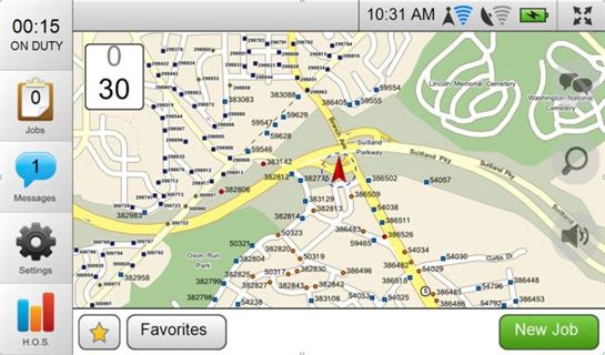
Data layers are stored within the Telogis Cloud, allowing them to be accessed via Telogis Fleet or Telogis Mobile. Telogis Layers enables end-users to route to relevant locations such as power poles, oil wells, gas and water lines, land use grids, and forestry and parcel data. Users can tab between different layers, providing them with clear and accurate details.

"The launch of Telogis Layers allows companies needing accurate and highly customizable GIS information to incorporate, categorize and label a variety of data sets in a very straightforward manner," said Newth Morris, president of Telogis' GeoBase Division. "The addition of Telogis Layers makes our SaaS-based mapping platform even more user-friendly, as it enables users to view any GIS data across multiple Telogis platforms."

"Telogis Layers makes it significantly quicker for us to rapidly deploy highly customized GIS systems for our clients," said Bill Ballard, president of Location Age, a geographic information and technology company headquartered in Silver Spring, Md. "Location Age manages complex systems integration projects for a wide range of organizations. The solution we chose needed to be able to handle the individual needs of our clients without the need for us to reinvent the wheel each time. Telogis Layers enables us to implement a high-quality solution while remaining competitive in the market."

Telogis Layers is available as an additional module for the Telogis Fleet platform. For pricing details, please contact Telogis' sales team at info@telogis.com or 866-TELOGIS (866-835-6447)

About Telogis
Telogis Inc., the platform for location intelligence, is dedicated to enhancing the value of our customers' businesses through intelligent integration of location technology, information and services. Telogis was established in 2001 and is headquartered in Aliso Viejo, Calif., with offices in Europe and Latin America as well as development centers Austin, Texas and in Christchurch, New Zealand. Telogis' products and services are used and distributed in more than 60 countries worldwide. To learn more about Telogis, visit www.telogis.com or call toll free at 866-TELOGIS (866-835-6447).

More Telematics

SponsoredJanuary 19, 2026

Basic Tracking vs Next Generation Fleet Technology

Fleet software is getting more sophisticated and effective than ever, tying big data models together to transform maintenance, safety, and the value of your existing tech stack. Fleet technology upgrades are undoubtedly an investment, but updated technology can offer a much higher return. Read how upgrading your fleet technology can increase the return on your investment.

Read More →
SponsoredJanuary 19, 2026

3 New Ways Fleet Software Pays: ROI opportunities for modern fleet managers

Public fleets face constant pressure to do more with limited budgets. This eBook outlines how modern fleet software helps agencies extend asset life, reduce unplanned downtime, and improve safety by automating maintenance, using smarter video insights, and unifying fleet data. A practical look at how technology can drive measurable ROI for taxpayers.

Read More →
SponsoredDecember 5, 2025

The Road to Smarter Electric Van Transitions: A practical roadmap for integrating electric vans into your fleet

Electric vans are becoming a strategic tool, not just a sustainability move. Get a roadmap that breaks down costs, charging planning, upfit compatibility, and what fleets should evaluate before making the switch.

Read More →
Ad Loading...
Telematicsby Jeanny RoaAugust 20, 2025

Distracted Driving and Samsara AI Safety

The U.S. public sector continues to use AI technology to combat the dangers of distracted driving.

Read More →
Person using Teletrac Navman’s TN360 fleet management platform on a desktop monitor displaying a world map and vehicle data, with the Teletrac Navman logo on a light background.
Telematicsby News/Media ReleaseJuly 11, 2025

Teletrac Navman’s TN360 Now Connects with Factory-Fitted Telematics for Easier Fleet Oversight

Agencies can now tap into factory-installed vehicle data within TN360 without taking vehicles out of service for hardware installs.

Read More →
Telematicsby News/Media ReleaseJune 10, 2025

Element, Samsara Partner to Launch Comprehensive Fleet and Operations Management Offering

This joint offering streamlines procurement and onboarding for shared customers to deliver greater safety and efficiency for fleets.

Read More →
Ad Loading...
Photo: Mark W. Clark
TelematicsAugust 19, 2024

7 Ways Fleet Intelligence Can Improve Safety, Savings, and Service

Fleet intelligence technology delivers actionable insights to optimize multiple aspects of government fleet safety and service.

Read More →
Telematicsby News/Media ReleaseJuly 19, 2024

How a South Carolina Fleet is Using Telematics to Improve Safety, Traffic, and Efficiency

Charleston County, South Carolina, has partnered with Geotab to bolster fleet operations through a telematics program.

Read More →
SponsoredJune 10, 2024

The Complete Fleet Management Software Buyer’s Guide

Purchasing Fleet Management Software (FMIS) is a critical decision requiring a significant investment and can transform your fleet operations. An outdated or non-user-friendly system can lead to missed opportunities for efficiency and cost savings. Whether you’re new to FMIS or looking to upgrade, our comprehensive guide covers the basics, latest advancements, and essential features to consider. Download our guide today to make an informed decision and optimize your fleet management.

Read More →
Ad Loading...
Telematicsby Nichole OsinskiMarch 15, 2024

How a Tennessee City is Using Samsara for Visibility into Safety, Service Delivery

Through the Samsara Connected Operations Cloud, the Memphis Public Works Division has been centralizing data across its 17 departments while also using the open API to integrate this data with critical business systems.

Read More →