Red Government Fleet with star logo
MenuMENU
SearchSEARCH

Zonar and Esri Integration Provides Real-Time GIS Mapping of Fleet Data

SEATTLE, WA - A new integration between fleet telematics provider, Zonar and geographic information system (GIS) provider, Esri delivers real-time fleet data layered with sophisticated geographic map information.

by Staff
April 9, 2012
Zonar and Esri Integration Provides Real-Time GIS Mapping of Fleet Data


2 min to read


SEATTLE, WA - A new integration between fleet telematics provider, Zonar and geographic information system (GIS) provider, Esri delivers real-time fleet data layered with sophisticated geographic map information.

The resulting system helps companies determine capacity enhancements, improve fuel efficiency, optimize routes and share interactive transportation maps on the web.

Early adopters of this technology use the integration to:

  • Determine fuel efficiency rates of specific routes with elevation information in addition to longitude, latitude, speed, odometer and fuel usage data.

  • Track vehicle location and diagnostic data in real-time on a map containing company facility and asset locations, preferred fuel stops, maintenance and service locations, or customer delivery points.

  • Provide advanced operational awareness via the integration of real-time vehicle locations with traffic, weather, work orders, and any company-maintained GIS data.

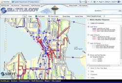
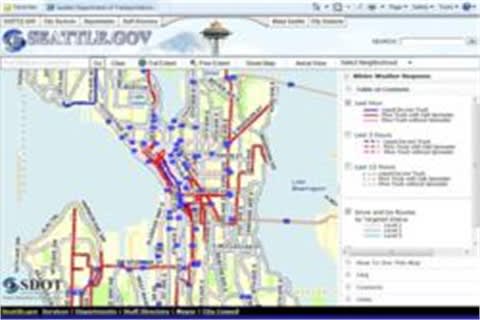
  • Publish web-based maps displaying real-time locations or recent activity of snowplows and whether the vehicle is actively plowing, de-icing or spreading salt.

“Esri is a perfect complement for Zonar fleet data,” said Mike McQuade, Chief Technical Officer at Zonar. “Zonar tracks longitude, latitude, odometer, speed and fuel, in addition to vehicle diagnostics in our core platform. Esri allows display of fleet locations and other data specific to their operation integrated through Esri’s mapping technology.

“Our customers asked for the ability to easily integrate fleet data into their own GIS” said Wolfgang Hall, Business Development Manager for Tracking Solutions at Esri. “It is very exciting that we can now help our users by merging the two technologies. The ability to display and store Zonar’s detailed GPS location data inside GIS allows our users to leverage advanced spatial analysis and to publish the combined data to mobile units and the Web.    

“Fuel efficiency is extremely important to our customers and the Zonar and Esri integration provides additional data sets including elevation to the fuel capture data Zonar provides,” adds McQuade. “In addition, private and public fleets are improving customer service by sharing interactive location maps and expected arrival information to customers over the Internet and mobile devices.”

Topics:Telematics

More Telematics

SponsoredJanuary 19, 2026

Basic Tracking vs Next Generation Fleet Technology

Fleet software is getting more sophisticated and effective than ever, tying big data models together to transform maintenance, safety, and the value of your existing tech stack. Fleet technology upgrades are undoubtedly an investment, but updated technology can offer a much higher return. Read how upgrading your fleet technology can increase the return on your investment.

Read More →
SponsoredJanuary 19, 2026

3 New Ways Fleet Software Pays: ROI opportunities for modern fleet managers

Public fleets face constant pressure to do more with limited budgets. This eBook outlines how modern fleet software helps agencies extend asset life, reduce unplanned downtime, and improve safety by automating maintenance, using smarter video insights, and unifying fleet data. A practical look at how technology can drive measurable ROI for taxpayers.

Read More →
SponsoredDecember 5, 2025

The Road to Smarter Electric Van Transitions: A practical roadmap for integrating electric vans into your fleet

Electric vans are becoming a strategic tool, not just a sustainability move. Get a roadmap that breaks down costs, charging planning, upfit compatibility, and what fleets should evaluate before making the switch.

Read More →
Ad Loading...
Telematicsby Jeanny RoaAugust 20, 2025

Distracted Driving and Samsara AI Safety

The U.S. public sector continues to use AI technology to combat the dangers of distracted driving.

Read More →
Person using Teletrac Navman’s TN360 fleet management platform on a desktop monitor displaying a world map and vehicle data, with the Teletrac Navman logo on a light background.
Telematicsby News/Media ReleaseJuly 11, 2025

Teletrac Navman’s TN360 Now Connects with Factory-Fitted Telematics for Easier Fleet Oversight

Agencies can now tap into factory-installed vehicle data within TN360 without taking vehicles out of service for hardware installs.

Read More →
Telematicsby News/Media ReleaseJune 10, 2025

Element, Samsara Partner to Launch Comprehensive Fleet and Operations Management Offering

This joint offering streamlines procurement and onboarding for shared customers to deliver greater safety and efficiency for fleets.

Read More →
Ad Loading...
Photo: Mark W. Clark
TelematicsAugust 19, 2024

7 Ways Fleet Intelligence Can Improve Safety, Savings, and Service

Fleet intelligence technology delivers actionable insights to optimize multiple aspects of government fleet safety and service.

Read More →
Telematicsby News/Media ReleaseJuly 19, 2024

How a South Carolina Fleet is Using Telematics to Improve Safety, Traffic, and Efficiency

Charleston County, South Carolina, has partnered with Geotab to bolster fleet operations through a telematics program.

Read More →
SponsoredJune 10, 2024

The Complete Fleet Management Software Buyer’s Guide

Purchasing Fleet Management Software (FMIS) is a critical decision requiring a significant investment and can transform your fleet operations. An outdated or non-user-friendly system can lead to missed opportunities for efficiency and cost savings. Whether you’re new to FMIS or looking to upgrade, our comprehensive guide covers the basics, latest advancements, and essential features to consider. Download our guide today to make an informed decision and optimize your fleet management.

Read More →
Ad Loading...
Telematicsby Nichole OsinskiMarch 15, 2024

How a Tennessee City is Using Samsara for Visibility into Safety, Service Delivery

Through the Samsara Connected Operations Cloud, the Memphis Public Works Division has been centralizing data across its 17 departments while also using the open API to integrate this data with critical business systems.

Read More →